home
retail
real estate
web design
move
here?
weather
email
me
![]()
|
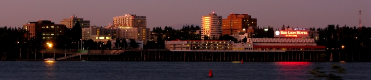
Clark County, what a place! Real Estate is all about, "Location, Location, Location!" Well Clark County is all about location. Just across the Columbia River from Portland, Oregon it has instant access to all that the metro area of 2.2 million residents offers. Theatre, sports, exhibitions, etc. The great outdoors is right out of your front door. Gifford Pinchot National Forest is just east of the urban area. Mt. St. Helens National Monument and Mt. Hood are an hour away. Skiing, snow-mobiling, hiking, boating, hunting and fishing, all just a few minutes away. I still can't believe how much there is to do in such a short distance.
Clark County may be America's best kept secret although many Oregonians are "discovering' it as they are moving here in mass. Clark County suffers a bit of an identity crisis as it is often associated with Portland. National media even tends to say and print things like, "Vancouver, Oregon". Local media loves to scream "WE ARE NOT OREGONIANS!" The city also suffers from "Vancouver? Isn't that in Canada?" Lovable former four term Mayor, Royce Pollard is always proclaiming it "America's Vancouver" and reminds the world that we were here first. (Vancouver, BC was incorporated nearly thirty years after us.) Wanna move here? Of course you do, who wouldn't? Events : May-Sept - Vancouver Farmers Market June - Portland's Rose Festival July 4 - Fort Vancouver Fireworks (largest barge show west of the Mississippi) July - Fort Vancouver Rodeo August - Clark County Fair August - Parade of Homes August - Portland's Brew Festival August - Vancouver Wine and Jazz Festival August - Uptown Village Street Festival December
- Christmas Ships on the Columbia River
|
 Nearby Portland
features Portland International Raceway which hosts many racing events each
year
Nearby Portland
features Portland International Raceway which hosts many racing events each
year and a spectacular Christmas drive through light display in December. The facility features a road
course and drag strip. The Portland Trailblazers NBA
basketball team and Portland Timbers MLS soccer team are also
close at hand. PGE park is a downtown urban ball park
reminiscent of a bygone era. Portland also has a fantastic zoo. Clark
County features the amazing Sleep Country Amphitheatre at the Clark
County Fairgrounds. This 8,000 seat facility which offers room for an
additional 10,000 on the grass features major musical
guests throughout the summer. Do you like golf? We have lots of golf
here. Check out my
and a spectacular Christmas drive through light display in December. The facility features a road
course and drag strip. The Portland Trailblazers NBA
basketball team and Portland Timbers MLS soccer team are also
close at hand. PGE park is a downtown urban ball park
reminiscent of a bygone era. Portland also has a fantastic zoo. Clark
County features the amazing Sleep Country Amphitheatre at the Clark
County Fairgrounds. This 8,000 seat facility which offers room for an
additional 10,000 on the grass features major musical
guests throughout the summer. Do you like golf? We have lots of golf
here. Check out my 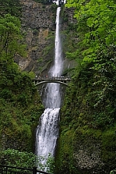 The coast is just 70
miles away. Seattle just 160 miles. The awesome Olympic
National Park and Mt. Rainier National Park are a short drive
away. But even if you never left Clark County, the scenery
here is truly breathtaking. A simple drive through Vancouver
offers picturesque views of the Cascade Volcanoes, the Columbia
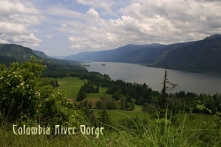
River, and the Gorge. Oregon's fabulous Multnomah Falls is less than
30 minutes drive. There are more trees than doggie heaven around
here. Around
every corner lies another glimpse of God's handiwork.
The coast is just 70
miles away. Seattle just 160 miles. The awesome Olympic
National Park and Mt. Rainier National Park are a short drive
away. But even if you never left Clark County, the scenery
here is truly breathtaking. A simple drive through Vancouver
offers picturesque views of the Cascade Volcanoes, the Columbia
River, and the Gorge. Oregon's fabulous Multnomah Falls is less than
30 minutes drive. There are more trees than doggie heaven around
here. Around
every corner lies another glimpse of God's handiwork.

 |
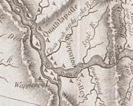
Click on the map to see information on that area. |
|
Settlement
History
:
This map was produced by Lewis and Clark, circa 1805
Historically Clark County is the oldest county in Washington. It has the first European settlement in the Northwest. Vancouver is also home to the oldest continuously active airfield in the United States, Pearson Field. Pearson was the landing site for the worlds first trans-arctic flight back in the 30's. |
|
|
|
Geography :
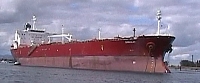
Clark County has 628 square miles of land, bounded on the East by the Cascades featuring prominent peaks, Mt. St. Helens (8345 ft), Mt. Adams (12,276 ft), and Mt. Hood, OR (11,245 ft). To the south and west by the mighty Columbia River and the state of Oregon. To the North by the Lewis River, Lakes Merwin and Yale. The Columbia river is Clark County's most prominent feature. This river is the main artery for the largest watershed in the West. This gargantuan river is over a mile wide at Vancouver. The Columbia features several active ports and lots of recreational activities.
|
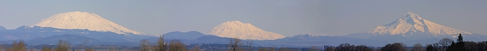
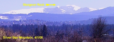 Highest
point in Clark County is a rocky outcropping called "Sturgeon
Rock" on the western down-slope of Silver Star
Mountain at just under 4,000 ft, the Lowest point is about 20 feet at the
Columbia River. Clark county features several 'plains' each at
varying elevations starting at about 100 feet and working north
towards Battle Ground around 400 feet.
Highest
point in Clark County is a rocky outcropping called "Sturgeon
Rock" on the western down-slope of Silver Star
Mountain at just under 4,000 ft, the Lowest point is about 20 feet at the
Columbia River. Clark county features several 'plains' each at
varying elevations starting at about 100 feet and working north
towards Battle Ground around 400 feet.| Economy
Typical climate Clark county has a
great climate. (Click here to visit my weather blog) The common perception is that the Pacific Northwest is all wet. Well, parts of it are. But the Metro Portland area features a real summer and only about 40-50 inches of rain per year which is less than most cities east of the Rockies. Most of the rainfall is spread out between October and June with the heaviest in the late fall and winter. There is a dramatic increase in the volume of rain received in areas in the vicinity of the Cascade foothills and Coastal mountains. Summers tend to be warm and dry. July and August each receive less than one inch of rain on average. Seasons There are four distinct seasons with none of them being severe.
Autumn is gorgeous with fabulous fall color blazing in late October through Thanksgiving. The foliage lights up enough to attract tourists from around the western U.S. The brilliance rivals New England. Temps get real cool at this time. By November highs will struggle to get into the 50's.
Spring is fabulous with less rain and flowers blooming everywhere. Warm air and cold air often mix bringing thunderstorms and small hail. Spring runs from March through June.
|
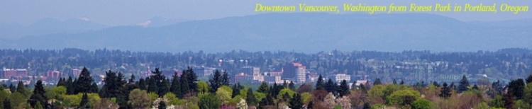
 Vancouver
is major shipping and manufacturing hub for Southwest Washington and
the Portland Metro Area, as well as the second largest city in the Portland/Vancouver
Metro Area. Industry is dominated by the Columbia River as the Port of
Vancouver and a huge rail yard provide a shipping point. High technology firms have a strong presence including Hewlett
Packard, SEH, Sharp and Wafer Tech. Although agriculture is still very
present the county's relatively small area limits major Mega-Ag
operations to exist. The Port of Vancouver has a large grain
exporting operation. There are also some large dairy farms in the
area.
Construction has been a strong industry including housing and
commercial. Even as housing continues to slide in 2011 hundreds of
millions of dollars in commercial and mixed use projects are planned
or under way in Vancouver. Clark County has a a 2011 estimated
population of 428,000.
Vancouver
is major shipping and manufacturing hub for Southwest Washington and
the Portland Metro Area, as well as the second largest city in the Portland/Vancouver
Metro Area. Industry is dominated by the Columbia River as the Port of
Vancouver and a huge rail yard provide a shipping point. High technology firms have a strong presence including Hewlett
Packard, SEH, Sharp and Wafer Tech. Although agriculture is still very
present the county's relatively small area limits major Mega-Ag
operations to exist. The Port of Vancouver has a large grain
exporting operation. There are also some large dairy farms in the
area.
Construction has been a strong industry including housing and
commercial. Even as housing continues to slide in 2011 hundreds of
millions of dollars in commercial and mixed use projects are planned
or under way in Vancouver. Clark County has a a 2011 estimated
population of 428,000.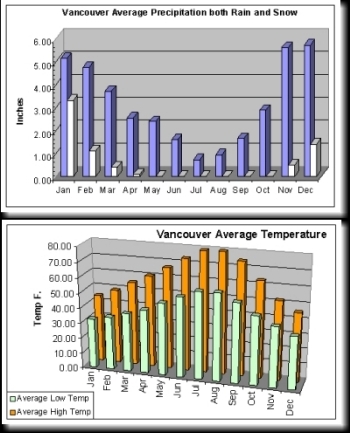
 Summer is short
running from July through mid September with highs in the high 70's
and low 80's. 90's are uncommon occurring on average less than
10 times a year. Over night lows are mild in the upper 50's
and low 60's. There is lots of sun as rain is scarce at this time.
Summer is short
running from July through mid September with highs in the high 70's
and low 80's. 90's are uncommon occurring on average less than
10 times a year. Over night lows are mild in the upper 50's
and low 60's. There is lots of sun as rain is scarce at this time. 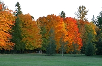
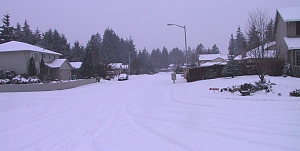 Winter
starts in December and runs through February. It is very mild
with lots of clouds, rain, and some snow and ice. Snow can be
anywhere from heavy to none. In the winter of 2002/2003 there
was no more than a trace of snow all season. Then 2004 started off
with a big cold snowy kick, 10-18 inches of snow around the county and a big ice
storm! (Historical
annual average 7 inches snow). Highs are typically in the upper 30's to mid 40's and lows in
the 20's and 30's. The sun is gone in the winter. Although it rarely gets above 50 degrees, bitter cold is
very rare
as over the last 100 years only a handful of times has the mercury dropped
below 0 degrees Fahrenheit in Vancouver.
Winter
starts in December and runs through February. It is very mild
with lots of clouds, rain, and some snow and ice. Snow can be
anywhere from heavy to none. In the winter of 2002/2003 there
was no more than a trace of snow all season. Then 2004 started off
with a big cold snowy kick, 10-18 inches of snow around the county and a big ice
storm! (Historical
annual average 7 inches snow). Highs are typically in the upper 30's to mid 40's and lows in
the 20's and 30's. The sun is gone in the winter. Although it rarely gets above 50 degrees, bitter cold is
very rare
as over the last 100 years only a handful of times has the mercury dropped
below 0 degrees Fahrenheit in Vancouver. 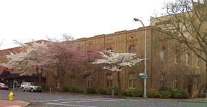
|
Cities
and Places :  Salmon Creek make up about
70,000 people. There are ten public high schools from three
districts serving the greater Vancouver area. additionally
there are several private schools, public continuation high school
and the Clark County Skills Center. Salmon Creek make up about
70,000 people. There are ten public high schools from three
districts serving the greater Vancouver area. additionally
there are several private schools, public continuation high school
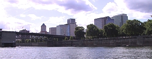
and the Clark County Skills Center.Vancouver has recently begun an ambitious redevelopment of it's formerly aged and decrepit downtown area. Click here for info on Downtown Redevelopment. Beginning with a beautiful restoration of Esther Short Park (the oldest public square in the Northwest) to the completion of mid rise and high rise apartment and condo buildings and the new Hilton Hotel and Convention Center, downtown is back with a vengeance. With hundreds of millions of dollars already poured into this brilliant revitalization, nearly a billion dollars more is forecast to be invested in other downtown projects and the opening of the Downtown Waterfront on the old Boise Cascade site. No city will be able to boast of such a fantastic waterfront on the mightiest river in the west. This city is well laid out and offers old fashioned neighborhoods with classic Norman Rockwell essence as well as Orange County style 'planned' suburban development. Controversial plans are underway to improve traffic over the Columbia River between Portland and Vancouver. Click here for info on Columbia River Crossing Project. The highway access is excellent with North and South routes covered by I-5, I-205, SR-503 and 164th Avenue. The East and West is covered by SR-14, SR-500, Padden Parkway, Mill Plain Blvd and Fourth Plain Blvd. I love this town! Here is an interactive panorama of downtown Vancouver, USA.
Washougal, 16.4 miles ENE of Portland, OR. 2011 Population 14,210, 5 sq miles. Eastern most city in Clark County. The Gateway to the Gorge! Literally, the entrance to the Columbia River Gorge National Scenic Area is just a few hundred yards beyond the city limits. The area also is host to a national Moto-Cross event each year. Washougal is a town that has grown dramatically over the last 2-3 years. The town features a river front area that is flat and filled with older homes and the downtown area. Then as you rise up the hillsides newer homes are everywhere. Washougal was host to several Clark County Parade of Homes in which magnificent homes are built and toured. Washougal still feels like a small town and is another great place to seek housing on small acreage. If you can't afford river front property on the Columbia (few people not named Gates or Buffet can) You may find charming water front property on Washougal's own river. The Washougal River runs From Camas through Downtown Washougal and up into the Cascade foothills. It's name is a Chinook Indian word for "Rushing Waters". Washougal High serves the community. Back to map. Ridgefield, 20.4 miles NNW of Portland, OR. 2011 Population 4,975, 5.1 sq miles. Don't let the population fool you, this town is ready to explode with I-5 access and a port on the Columbia. Much building is underway including a large commercial and industrial area right on I-5. In the last 5-10 years many affluent people have moved into the area building custom homes on small acreage. Ridgefield has a great little town center and the Ridgefield National Wildlife Refuge is a bird watchers dream. Ridgefield High serves the community. Back to map. Woodland, 26.4 miles North of Portland, OR. 2011 Population 5,550 only 85 in Clark county, 2.6 sq miles. Woodland is actually the southernmost city in Cowlitz County but 85 of it's residents are in Clark County. Woodland is a town with allot to offer including good values on real estate. It is just 20 miles north of Vancouver and less than 30 miles to Downtown Portland yet locals act like it's on the moon. The Lewis River brings fresh mountain water through the heart of this town and it is the gateway to the 3 large reservoirs above, Merwin, Yale and Swift. This town also has a great golf course. Lewis River Golf Course includes a monster 687 yarder amongst it's 18 gorgeous holes. Tiger can't even hit that green in two shots. Woodland High serves the community. Back to map. La Center, 23.5 miles North of Portland, OR. 2011 Population 2,835, 0.9 sq miles. This is a gamblers haven with several card rooms and small casinos run by local Native American tribes and other business people. This charming town is in the middle of a big controversy over the plans for a HUGE casino to be run by the Cowlitz Indians. La Center has easy I-5 access and is away from the hustle and bustle of the city. It's high school draws only those students that are in close so it is small and charming. The city ranges from 100-300 feet in elevation. Back to map. Yacolt, 26.9 miles NE of Portland, OR. 2011 Population 1,585, 0.5 sq miles. No, it's not the smallest incorporated city in Washington state, in fact not even close as it is ranked 181 (tie with Winlock) out of 281. It is however Clark County's smallest incorporated city. If you tell people in Vancouver that you're from Yacolt, they look at you like you just said Mars. If you tell people from Portland the same thing they say "Where?" But this great little town is not that far away. It is just about a dozen miles by road from Battle Ground. It is up in the Cascade foothills and you can rest assured no new freeway projects are likely to find there way here. But at an elevation of just under 1,000 feet this town gets allot more snow in the winter and backs up to the great open wilderness of DNR Forest and the Gifford Pinchot National Forest. Back to map. Brush Prairie, 15.8 miles NE of Portland, OR. There is actually a town of Brush Prairie, it is located just off SR-503 but it really represents a large area of small ranches and McMansions on small acreage from Vancouver/Orchards to Battle Ground. The Chelatchie-Prairie Railroad offers excursions on an old fashioned steam train into the mountains. Most of this area including the town itself is unincorporated (2000 census population 2,384) but parts of Brush Prairie are slated to join the City of Vancouver soon. The area includes Prairie High School which is well known for it's Championship Basketball program for both Boys and Girls. Back to map. Hockinson, 17.3 miles NE of Portland, OR. This charming little town looks like Mayberry, USA but it has it's own High School, Middle School and two grade schools in it's own school district. The town represents a much larger area that includes very affluent homes in the Cascade foothills. (2000 census population 5136) Hockinson is entirely unincorporated. Back to map. Amboy, 28.9 miles NE of Portland, OR. This town is halfway to the lakes from Battle Ground. It features a middle school and grade school as well as a small town center. Amboy is entirely unincorporated (2000 census 2,085) and includes a large rural area. Back to map. Dollars Corner, 18.1 miles NNE of Portland, OR. Dollars Corner is a small unincorporated town that is named for the Dollar family. The "town" is little more than one intersection with some cute shops and services. It is a census tract area that covers a good sized rural area. (2000 census population 1,039). There are several antique and second hand stores in the area. Back to map. Lake Merwin Back to map. Yale Lake Back to map. Gifford Pinchot National Forest Back to map.
|
|
Major
Parks : Click here for
map (Park is located in Cowlitz and Skamania Counties but lies within a mile of Clark County)
Columbia River Gorge National Recreation Area (262,000 acres)
Gifford Pinchot National Forest (1,368,300 acres) Fort Vancouver National Historic Reserve (210 acres) Ridgefield National Wildlife Refuge (5,150 acres) Vancouver Lake Park (234 acres) Battle Ground Lake State Park (280 acres) Paradise Point State Park (88 acres) Salmon Creek Park / Klineline Pond (368 acres) Moulton Falls State Park (301 acres) Lucia Falls Park (24 acres) Lacamas Park (312 acres) Lewisville Park (154 acres) Frenchman's Bar Regional Park (120 acres) Daybreak Park (35 acres) Marine Park (26 acres) Cedar Creek Grist Mill National Historic Site (12 acres) Cottonwood Beach Park Wormwald State Park (160 acres) |
Copyright, 1994-2011, Rod Sager, Evergreen Online Enterprises, all rights reserved. Vancouver, Washington, USA
Sources : Population estimates, Washington State Department of Finance, April 2011. Geographic facts, US Geological Survey
("Feels so Good" - Chuck Mangione, Album "Feels so Good" 1977 A&M records)